|
1月1~2日(土~日)
Jan 1 to 2.
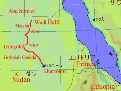
地図は
Fland-Ale 日本世界地図 Ver 3.71を使用。
I used map data "Fland-Ale" and arranged it.
昨日の金曜日とは打って変わって活気があるアブリの町を午前中に出発。
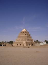
15kmほど先の「クワッカ (Kwakea) 」にて、地元の聖者が眠る棺が納められている
「グッバ」を見学してから、南へ目指す。しかし、「サディフェンテ (Sadifente) 」付近で
再び防振ゴムが破損。応急処置を施すが片側は脱落して無くなる。
気温も30℃近くあって疲労気味。ナイル川沿いの村々には「ミスィート」と言う宿泊可能な場所があるので、
サディフェンテから15kmほど南の小さな村「アブサン (Absan) 」のミスィートにテントを張る。
再びシャーイ(紅茶)と食事を地元の人から頂いていた。親切がありがたい。
Today is new year start day. Town market was opend and had activity,
town atmosphere was totally different yesterday. We started to go to South.
After 15km driving, we arrived small village "Kwakea" and watched one building
"Gubba" it is grave for this village holy man and his families.
We left here and drove, but my tank rubber cushion was broken near Sadifente.
I think it cause was aged deterioration. I did a quick fix.
In this evening, we stayed at "Miseet" it is sleeping place for travelers in a small village "Absan".
Along the Nile river villages have Miseets, travelers can use them.
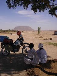 
左:クワッカにて「(前方の岩山を指差し)あの名前は?」と尋ねると
「ジェベル(山)」とアラビア語で答えられ、ビックリ。
こんな所で自分のバイクの名前が出てくるとは。
右:聖廟でもあるグッバ。土とレンガの作り。
Left: I asked local people "What is this mountain name?", and it answer was "DJebel" it mean is
"mountain" in Arrabic. ("DJebel" is my motarcycle's name!)
Right: Gubba was build on blick and soil.
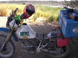 
左:バイク修理中。それにしても小バエが物凄い。耳の中まで入ってきて大変・・・。
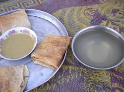
右:頂いた食事。茶色い水だが、大切な水。
Left: When I repaired my moto, many small flies came me. One fly invaded in my ear.
"Please get away!"
Right: Local people presented us a dinner and water. Water was mushroom color but
very valuable water.
翌朝、ここら辺で一番大きな町である「ドンゴラ (Dongola) 」を目指す。
アブサンから南へ40kmほど進み、「ファレック (Farec) 」から「ケルマ (Kerma) 」への
内陸ルートを通る。川沿いは砂深いらしいので迂回ルート。ケルマから60kmほど南にある
「アルゴ (Argo) 」で船に乗り(アラビア語で小型の船を「ボントツ」)、ナイル川を渡って
更に40kmほど走ると、北部で一番大きな町であるドンゴラへ到着した。
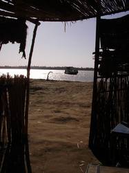
ボントツでのナイル渡りをしている最中、西日を浴びて水面をキラキラと輝かせていたナイルが
素晴らしく美しく、そしてとてつもなく輝いて見えた。
おそらく何気ない景色なのだろうが、この時に初めて「アフリカへ来て良かった」、
と心の底から思えて嬉しかった。こんな気持ちはもう二度と味わえないだろう、と思う程に。
Next day, we started to Dongola. After 40km driving, we arrived at Farec, and selected
escape road to Kerma. Because the road along the Nile is short but deep sand.
Escape road was somtimes soft sand, so I never retured accelerator grip on soft sand.
Between Kerma and Argo was about 60km. We arrived Argo and boarded a ship across the Nile.
("Bon totsu" mean is a small ship in Arabic.")
The sunshine from west was reflected on the Nile and the surface of Nile was brilliant.
I felt "How beautiful sene!" at the bottom of my heart, and I could glad "Traveling at Africa
is very very happy for me.".
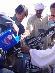 
左:ファレックでガソリン補給。沿道に日本の様なスタンドはアブリ、ドンゴラ、ムタガにしか無く、
オイル缶に入れたガソリン(ベンジーン)を買って入れた。
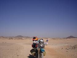
右:ファレックの迂回路にて。砂漠さばくサバク。
Left: We bought fuel at Farec. Along the road from Waddi halfa to Khartoum,
there was no GS without Abri, Dongola, Mutaga. So we had to buy this type fuel.
Right: On the escape road to Farec. Only desert and rock mountain.
左:ケルマ近くの村にて。シャーイ(紅茶)をご馳走になったが、
ケルマから沿道に置いてある水瓶は透き通る美味しい水に変わっており、シャーイも美味しくなっていた。
右:アルゴの船乗り場にて。(所要時間約50分で250 SD)
Left: At near Kerma. There are many water bottles like this one.
Right: Ferry port at Argo. (Trasport time was about 50 minutes, we paid 250 Sudan Dinar.)
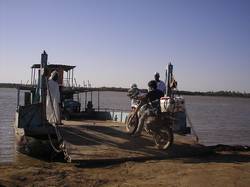 
左:こんな船に乗り込む。
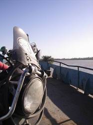
右:船上にてナイルを臨む。
Left: The ferry to across Nile rivver.
Right: View from on the ferry.
|